About Bayou Pigeon, Louisiana
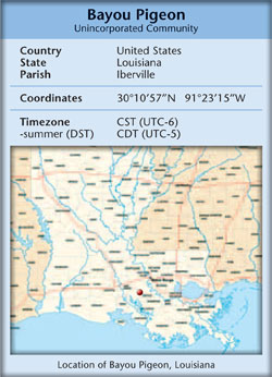 Bayou
Pigeon, Louisiana, is a small unincorporated village located near
the southern tip of Iberville Parish, in the state of Louisiana,
and in the great country of the U.S.A. It is found on the eastern
edge of the Atchafalaya River Basin and is part of the Atchafalaya
National Heritage Area.
Bayou
Pigeon, Louisiana, is a small unincorporated village located near
the southern tip of Iberville Parish, in the state of Louisiana,
and in the great country of the U.S.A. It is found on the eastern
edge of the Atchafalaya River Basin and is part of the Atchafalaya
National Heritage Area.
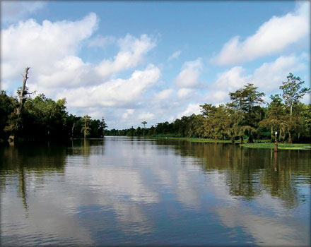
The climate of Bayou Pigeon is mild with less than three months of winter. Annual rainfall is approximately 60 inches. The cypress/tupelo swamp is abounding in Spanish moss and wild game.
 The
story of Bayou Pigeon begins with the history of the modern
Atchafalaya River Basin starting from the third decade of the 19th
century, i.e. the 1830’s until present day.
The
story of Bayou Pigeon begins with the history of the modern
Atchafalaya River Basin starting from the third decade of the 19th
century, i.e. the 1830’s until present day.
Bayou Pigeon is best known for its Cajun culture and the life ways of the local residents. How they are directly related to the natural resources of the Atchafalaya River Basin; fishing, crawfishing, trapping and hunting.
![]()
Bayou Pigeon, Or Pigeon, What Is the Correct Name?
The USGS department of the Federal governmentnames the community as Pigeon. The official LA Dept. of Highways map refers to the community as Pigeon. The Iberville Parish online internet web site,2010 map refers to the community as Bayou Pigeon. Wikipedia, the online encyclopedia refers to the community as Bayou Pigeon.
An informal / antidotal survey of residents old and young, documents that both terms are used interchangeably. Since the US Postal Service uses a Plaquemine address for the area and the community is unincorporated, it is logical to conclude that both are correct.
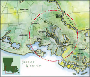
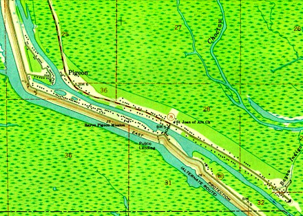
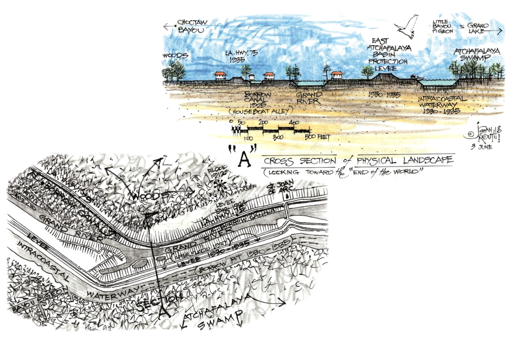
The landscape of the community is set up in linear format along Lower Grand River at the confluence of Little Bayou Pigeon and Lower Grand River with the residents making homesteads along the high ground. There is one bridge across that joins the residents who live on both sides. The geographic location is 30.04.'10.70" N - 91.17' 07.30" W.
![]()
The primary route to Bayou Pigeon is south from Plaquemine, via
Louisiana highway 75. It is bordered on the west by the East
Atchafalaya basin protection levee, Louisiana highway 404 to the
north, and Iberia parish line to the south and hwy. 75 on the
east. History buffs and local historians are usually excited about
the origin of place names. However, many examples exist that have
shown how quickly and completely the origin of names can be lost
in a short period of time.
Origin of the name Pigeon Bayou and or Bayou Pigeon
What is known, is that in the early 1800's it was common for trappers and explorers to name a stream or bayou by either a descriptive term or a surname, (William Read, Louisiana Place Names). As writers/ researchers we have not found written objective evidence for the naming of Bayou Pigeon, however it is intuitively obvious that the name Pigeon came from a descriptive term.
Early documentation from the 1800's indicates that Louisiana and the Atchafalaya River Basin Swamp was visited annually by millions of passenger pigeons. More than likely the Passenger Pigeon birds would have been drawn to the current Little Bayou Pigeon area near its confluence with Grand Lake. Passenger pigeons were known for feeding, roosting, and breeding in oak trees. Anyone familiar with the area of Little Bayou Pigeon at Grand Lake knows of the existence of the abundance of live oak trees that follow the bayou's natural ridge for several miles from its confluence with Grand Lake.
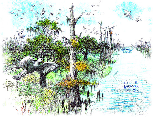
![]()
Passenger Pigeons were flocking birds, they migrated many
thousands of miles to exploit the vast food supplies they needed
for their nomadic congregations. Early observers believed that the
birds remembered areas with good fall mast crops and returned to
nest there year after year. The migrations of millions of
passenger pigeons to an area would catch anyone's attention.
Most historians and birding people that the authors / researchers discussed this topic with, believe that the most likely explanation for the name is early explorers usually had an Indian guide and / or local fur trapper traveling with them giving them names, if one existed, for the local streams.
It is also logical to believe that one of the early American explorers, Cathcart, Darby, or Ludlow, may have taken it upon himself to name the stream or bayou, i.e., Pigeon Bayou, after personally observing the birds flocking there. Maxfield Ludlow specifically called out Pigeon Bayou in his maps 1812-1815.
Bayou Pigeon is best known for its Cajun Culture and the life
ways of the residents and how they arerelated to the natural
resources of the
Atchafalaya River Basin; fishing, crawfishing, trapping, and
hunting.
Catholicism is the predominant faith, however with the 2017 closing of St. Joan of Arc Catholic Church as noted on this web site there is no organized church in the community. Despite the predominance of Roman Catholicism, there once was a Southern Baptist congregation in the village from the 1960s to the late 1980s, known as Bayou Pigeon Baptist Church and led by Rev. George W. Ray (1912–1992).
Pierre Part, La. – Bayou Pigeon, La. Connection
The Cajun residents of Bayou Pigeon trace their ancestry from Pierre Part, La., another small Cajun Community in nearby Assumption Parish.As late as the 1950’s, Cajun French was the dominate language
spoken in 90% of the households in Bayou Pigeon. It continued to
be the predominant language until the early 1970’s and can still
be heard in the older resident's homes.
The community of Bayou Pigeon was predominantly of Acadian / Cajun Ancestry until the 1980’s.
|
JOIN THE BAYOU PIGEON HERITAGE ASSOCIATION |
 OR
MAKE A DONATION in any amount |
|
|